11 Feb Yaqan Nukiy History on Kootenay Lake
Here is some interesting information about the history of the Yaqan Nukiy – Lower Kootenay Indian Band who have been living by Kootenay Lake for over 10,000years (informaiton quoted from http://lowerkootenay.com/our-community/our-history/):
The Yaqan Nukiy is one of four Canadian and 2 USA bands which make up the Ktunaxa Nation (pronounced ‘k-too-nah-ha’). The other 4 Canadian Bands formed the Upper Kootenay portion of the Ktunaxa and are all located in British Columbia – Akisqnuk near Windermere, Aqam near Cranbrook, and Tobacco Plains near Grasmere. The USA Bands are called tribes and are the Confederated Salish Kootenai near Elmo, Montana, and Kootenay Tribe of Idaho at Bonner’s Ferry.
The Traditional Territory of the Ktunaxa Nation covers approximately 70,000 square kilometres (27,000 square miles) within the Kootenay region of south-eastern British Columbia and historically included parts of Alberta, Montana, Washington and Idaho.
The people of Yaqan Nukiy speak the Ktunaxa language which is one of the eleven original aboriginal language families in Canada. The language is isolated and is not related with any other language in the world.
Prior to European contact, the people were semi-nomadic and traveled great distances within the Ktunaxa Traditional Territory. The waterways, primarily the Kootenay River formed the existence and link to all the communities of the Ktunaxa Nation confirmed by the Ktunaxa creation story. Historically, before man was made, the land was inhabited by animals and animal spirits. The animals and spirits whom the Creator (Nupika) created, told these animal spirits that they would have to move up above to be our guardians and that only their forms in spirit, language, songs and dances could be left behind to help the Ktunaxa people in the territory. It was then and during the making of the human beings that the Creator made the sacred convenants that the Ktunaxa people have to live and abide by in order to survive in this territory which Nupika has placed. Connection to the Kootenay River is highly regarded as the transformation route by Man Spirit (kikum) whom travels the waterways by canoe and makes his home in Kootenay Falls to give healing, mental and physical spirituality and to bring messages when called upon by spiritual leaders and medicine men.
The sweatlodge was one of the main structures left for the people to utilize for purification, prayer and for mental, physical and spiritual healing. It was uncommon to find a home or family without a sweatlodge in Yaqan Nukiy, and many people today still utilize the sweatlodge.
It is no surprise that the people of Yaqan Nukiy settled along the Kootenay River and at the south end of Kootenay Lake. Along with the spectacular view of the Creston Valley, it has a vast wetland as well as many streams and tributaries that flow into the slow moving river. Prior to European settlement, the Kootenay River overflowed its banks every spring depositing a rich silt load over the valley floor as well as replenishing the wetlands associated with it.
Culture, traditions and language were the mainstay of the people while hunting, fishing, trapping and the gathering of roots and berries formed the basis of survival and livelihood.
The major vehicle utilized for travel was the Kootenay Canoe (Yaksumit), This craft was utilized extensively to travel up and down the Kootenay River, into the wetlands and Kootenay Lake for all sustenance activities. The canoe was an important part of the social, ceremonial and religious activities as well. The Yaksumit is widely known for its unique design, with its sturgeon nose shape, front and back, the canoe lies flat from stern to stern. Quite often, it lies below the surface of the water and terminates at both ends in a point that resembles the nose of a sturgeon. The entire bottom of the craft between the points is level and the points extend outward from the gunwale so that the canoe is considerably longer on the waterline than on top. The canoe was made from natural materials, all found within the Creston Valley. The covering of the canoe was made out of the bark of the Western White Pine with Birch bark being utilized for the top 4-6 inches. The inside of the bark served as the outside of the canoe. Cedar, cedar roots, maple sap or pitch from coniferous trees were the main materials used for the building of this craft. After European contact, the Ktunaxa were introduced to canvas which was used to cover the yaksumit. Today, canvas is still utilized by the remaining elders whom possess the skills and knowledge of crafting and building the canoe.
Historically, the dwelling of the Ktunaxa was the teepee. It was a simple and common structure, as it was the universal lodging of most First Nations people. The Ktunaxa teepee is a four pole base structure and would be 10 to 12 feet high depending upon family size. In the Upper Kootenay area, elk, deer, moose and sometimes buffalo hides were used. In the Lower Kootenay, the Yaqan Nukiy utilized tule (bulrush) for their covering. The tule were matted together and placed in layers beginning from the bottom. The summer shelter was a simple cone framework of light poles and mats or skins which could be easily dismantled and packed, ready to move on a moment’s notice. The winter dwelling was a more modified type of teepee structure with permanent framework and weather proof covering. Other dwelling structures used by the people included make shift lean toos and round huts. The pit house was not common among the Ktunaxa, however, it was sometimes used by families created through intertribal marriages with the neighboring Salish tribes.
Water for domestic use was packed by pine bark baskets and rawhide water bags from the Kootenay River and numerous streams and springs in the area.
The social and government structure of the people relied upon the leaders of the tribe. Chiefs were appointed to carry out all sustenance activities of the tribe in relation to the seasons. These appointments were for the lifetime of that person. The women accompanied the men to assist in hunting and fishing, and were the main gatherers of berries and roots. The woman also helped to prepare and tan fur bearer’s hides, particularly of muskrat and beaver. They were very proud of their craftsmanship in preparing the white and smoked buckskin. Other items that were made include dresses, moccasins, gloves, gauntlets, leggings, warshirts, jackets, robes, shawls and beadwork. The people were generally non- warring but became very active when provoked from neighboring tribes.
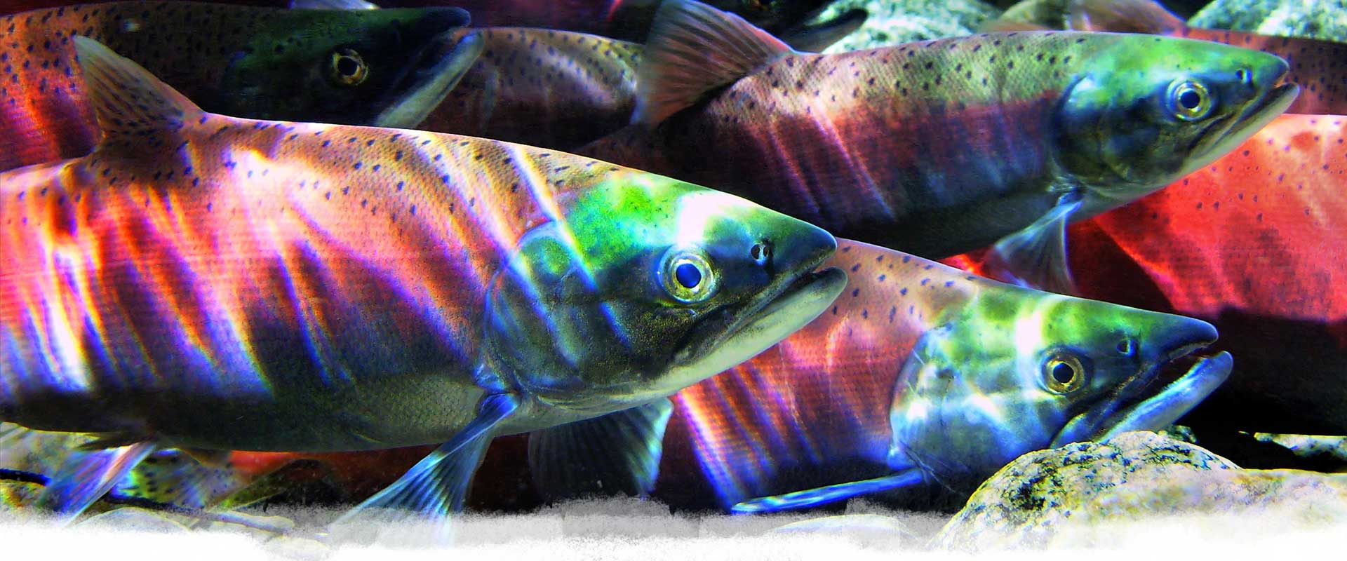
The main diet of the Yaqan Nukiy people was wild game, especially deer, balanced with fish and waterfowl and supplemented with berries and roots. The most sought after fish species included trout, kokanee, bull trout, burbot, and sturgeon.
The Yaqan Nukiy people utilized several different methods for harvesting fish, waterfowl and wild game. For wild game harvest, corrals with entrances were built in a circular fashion and were heavily covered with brush to hide the bowman. Hunters with dogs would drive the deer into these corrals, where they would be shot by the bowman. The corrals were easily dismantled and could be moved to other areas until there was enough meat to feed the entire community. Individuals also went out on their own to hunt deer only if they wanted fresh meat. Similar methods were used in harvesting fish. Weirs would be placed in the stream about 4 to 6 feet apart. The fish would be driven into a large shallow pool and trapped in the cone shaped weir. Fish spears and hooks were also used by individuals to catch the larger fish in the lake and river.
The method used to harvest waterfowl was very unique. No weapons were used. The people picked areas where the end of a pond narrowed creating an obvious escape route for the waterfowl. At one end of the pond, the people erected poles that stood out of the water 20 to 30 feet in height. Nets were erected from these poles. Utilizing the canoe, the waterfowl were driven from the tules and bulrushes into open water by splashing the water with paddles, clapping hands and hollering. The ducks would swim towards the narrow points of the pond and take flight, thus tangling themselves in the erected nets. The poles and net were taken down and the ducks were collected. This was repeated at different sites within the wetlands until the harvest is complete and there was enough waterfowl to feed the community.”